11 May 2014
Mike asks I am interested in what you are using as navigation equipment, software and other electronics? We will be updating 14 year old gear in the coming months.
As an electrical engineer I learned long ago that water and electronics don’t mix. So I’ve kept the electronics at a low level.
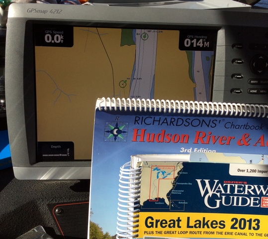
The prior owner installed a very nice Garmin GPS unit. I use that for most of the travels so far. It has the charts from 2012 so it’s pretty current.
I’m a big fan of paper charts since they work under all sorts of adverse conditions. I have charts for the entire trip (hey Mike call me before you leave on the loop for a good price on gently used charts). that I use to plan.
For the US segments I have the Dozier’ Waterway Guides. They have where to go, what to see, etc in printed format. For Canada I have similar books published by PORTS. They have one for the Trent-Severn and for the North Passage. Great reading, gives some decent insight to the trip. You also get weekly email updates on things that are happening in the area.
I have an iPad that I run iSailor on. iSailor is super simple and fits my needs of being a chart plotter. There is better software from Garmin and Navtec that you might want to look at first. I also have an AIS app that will give me some info about traffic in my area. I don’t use it to navigate, but I do pull the ships name. I get better response when I go “Calling Godzilla, calling Godzilla” to the giant freighter vs “Hey you in the channel”
I belong to the America’s Great Loop Cruisers’ Association. It’s $40 a year and I’ve saved more than that on Dock fees the first two weeks. But for docking it’s great, there is a section for each part of the trip and places to stay (and stay away from).
I also have an Active Captain account to look at reviews. It could be better some reviews are dated, but hopefully as 2014 kicks off there will be current reviews posted. It’s a free service.
Membership in the Waterway Guide Cruisers Club may also be helpful. Presently membership is also free.
Last I have a compass. So that and the charts serve me well.
The boat came with RADAR which I can use, but seldom do. If it’s too foggy out, I stay at the dock. When we came through NYC harbor there was very little boat traffic so I relied on the Mark I eyeballs.
The only electronics that I’m really attached to is the autopilot. It makes the long periods of driving super easy. I still drive in the tight places, but in the Chesapeake Bay and the ocean, nice to set it to 29 degrees north and let it drive for the next hour.
Good luck on your purchase. As we get closer to you in Oct/November drop another note in and we’ll try to meet up.
Many thanks. Very helpful. I may well be in touch as you complete the trip. Mike